

"Koh Tan Green Plus Island
มากกว่าแค่การท่องเที่ยว คือการเติมเต็มพลังให้ธรรมชาติและตัวคุณ พบกับความสงบที่ลงตัวที่สุด ณ เกาะแตน"
"เปิดประสบการณ์สู่หัวใจของเกาะแตน กับ 'เกาะแตน กรีน พลัส ไอส์แลนด์' พื้นที่แห่งการเรียนรู้และการค้นพบธรรมชาติที่ไร้การปรุงแต่ง สัมผัสความมหัศจรรย์ใต้ท้องทะเลและวิถีชีวิตที่เรียบง่าย แบบฉบับกรีนพลัสที่คุณจะต้องหลงรัก"
"Experience the heart of Koh Tan with 'Koh Tan Green Plus Island' — a sanctuary for learning and discovering nature in its purest form. Immerse yourself in the wonders of the sea and the simple island lifestyle, the 'Green Plus' way that you are sure to fall in love with."



KOH TAN
ความสําคัญของเกาะแตน
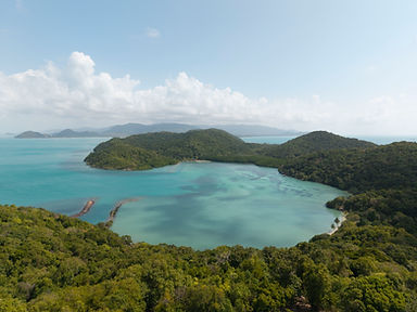
เกาะแตน หรือเกาะกระเต็น เป็นเกาะขนาดเล็กเกาะหนึ่งในหมู่เกาะทางทิศตะวันตกของอ่าว ไทย ซึ่งประกอบด้วยเกาะสมุย เกาะพะงัน เกาะเต่า และหมู่เกาะอ่างทอง เกาะแตนอยู่เขตตําบล ตลิ่งงาม อําเภอเกาะสมุย จังหวัดสุราษฎร์ธานี ตั้งอยู่ทางทิศใต้ของเกาะสมุย มีระยะห่าง 2 กิโลเม ตร บริเวณประมาณเส้นละติจูดที่ 9 22 ' เหนือ และเส้นลองจิจูดที่ 99 54 ตะวันออก (ภาพที่ 1) เกาะแตนมีรูปทรงเป็นรูปสามเหลี่ยมยอดแหลมหรือคล้ายเจดีย์ ขนาดเกาะมีความกว้าง 3 กิโลเมตร และยาว 4.5 กิโลเมตร คิดเป็นพื้นที่ประมาณ 7.5 ตารางกิโลเมตร เกาะแตนมี ภูมิประเทศเป็นภูเขา 3 ลูก คือเขาเคี่ยม ทางตอนใต้มียอดสูงสุด 218 เมตร จากระดับน้ําทะเล มีสภาพป่าค่อนข้างสมบูรณ์ เขากลาง เป็นเขาลูกเดียวโดดๆ อยู่กึ่งกลางเกาะ และเขาตีน เป็นเขา
ตอนเหนือ วางตัวเป็นแนวยาว
ฝั่งตะวันออกของเกาะเป็นชายหาดยาวขนานกับแนวปะการังชายฝั่ง (เรียกว่า อ่าวออก) ส่วนฝั่งตะวันตกเป็นอ่าวปิด มีป่าชายเลนผืนเล็ก และหาดหิน (เรียกว่า อ่าวตก) และมีแนวปะการัง ชายฝั่งที่ค่อนข้างสมบูรณ์ รอบเกาะมีแนวชายฝั่งยาว 14.5 กิโลเมตร มีลักษณะเป็นหาดทราย 1.5
กิโลเมตร หาดหิน 4 กิโลเมตร หาดเลน 1.5 กิโลเมตร และหน้าผา 7.5 กิโลเมตร นอกแนวชายฝั่ง ด้านทิศตะวันออกและทิศใต้ มีแนวปะการังที่สวยงามและอุดมสมบูรณ์
Significance of Koh Tan
General Information Koh Tan, also known as Koh Kraten, is a small island situated in the western archipelago of the Gulf of Thailand, which includes Koh Samui, Koh Phangan, Koh Tao, and the Ang Thong National Marine Park. Administratively, it is located in Taling Ngam sub-district, Koh Samui district, Surat Thani province. The island lies approximately 2 kilometers south of Koh Samui, positioned at approximately 9°22'N latitude and 99°54'E longitude.
Geography and Terrain Koh Tan is characterized by its triangular shape, resembling a pointed pagoda. It measures 3 kilometers in width and 4.5 kilometers in length, covering a total area of approximately 7.5 square kilometers. The island’s topography features three distinct mountains:
-
Khao Khiam: Located in the south, reaching a maximum elevation of 218 meters above sea level with relatively pristine forest cover.
-
Khao Klang: An isolated peak situated in the center of the island.
-
Khao Teen: A mountain ridge stretching across the northern part of the island.
Coastline and Ecosystems The island offers diverse coastal environments:
-
Eastern Coast (Ao Ok): Features an extended sandy beach running parallel to a vibrant coastal coral reef.
-
Western Coast (Ao Tok): A sheltered bay characterized by small mangrove forests and rocky beaches.
The total coastline spans 14.5 kilometers, comprising 1.5 km of sandy beach, 4 km of rocky beach, 1.5 km of mudflats, and 7.5 km of cliffs. Furthermore, the offshore areas to the east and south host beautiful, flourishing coral reefs.